On the morning of July 22, 1793, on a large rock at the edge of Dean Channel, a long inlet of the Pacific on the coast of what is now British Columbia, a twenty-nine-year-old Scottish fur trader named Alexander Mackenzie mixed some vermilion into melted grease and painted a line of words on the stone's southeast face: "Alexander Mackenzie, from Canada, by land, the twenty-second of July, one thousand seven hundred and ninety-three." He and his companions had spent the night on the rock, uneasy about the people around them. The afternoon before, a man in a canoe had told Mackenzie, with what he took for insolence, that a large vessel carrying men like him had lately been in the bay, and that one of them, whom the man called Macubah, had fired on him and his friends. Macubah was very probably Captain George Vancouver of the Royal Navy, who had explored Dean Channel on June 2. Mackenzie's crossing and Vancouver's survey of the coast had missed each other by about seven weeks.[1]
The inscription was a modest claim, and it covered a more complicated story. Mackenzie's two great journeys, down the river that now bears his name to the Arctic Ocean in 1789 and across the mountains to the Pacific in 1793, were sent out by a fur-trading partnership looking for a commercial route, and in that sense both fell short. The first reached the Arctic instead of the Pacific. The second reached the Pacific by a route the later fur brigades did not follow. Both relied at almost every stage on Indigenous guides, interpreters, and trails, and on French Canadian canoemen whose names rarely appear in the story. What Mackenzie did afterward mattered as much. He left the western country, quarreled with the most powerful man in the Montreal fur trade, and in London turned his journals into a book. Published at the end of 1801, it presented his travels as an argument for a British-backed fur trade spanning the continent, and it found readers far beyond the trade, including the president of the United States. This is the story of those twelve years.
A Clerk from Stornoway
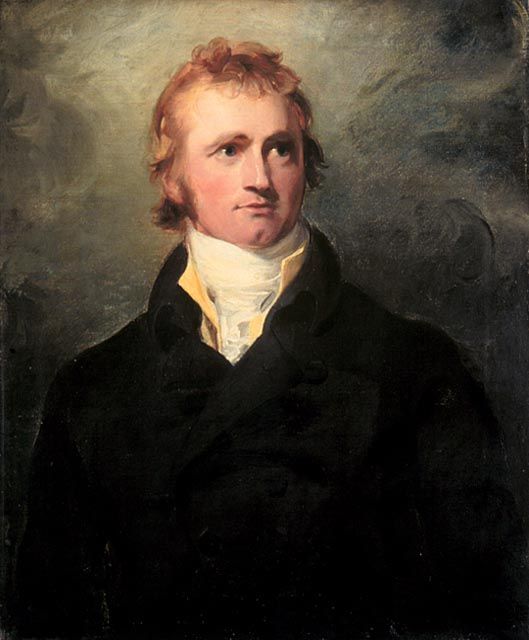
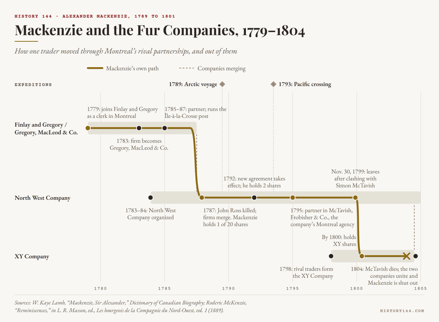
Mackenzie was born at Stornoway, on the Isle of Lewis in the Outer Hebrides, in 1764 according to the Dictionary of Canadian Biography, though other accounts place his birth around 1762.[2] Hard times on the island drove his father to North America in 1774, and by 1778 young Alexander was in Montreal. The following year he joined Finlay and Gregory, a firm trading furs in the west, and spent five years in its counting house. In 1784 his employers, impressed by his handling of a small consignment of goods at Detroit, offered him a share in the business on condition that he serve in the far west. From 1785 to 1787 he ran the firm's trade at Île-à-la-Crosse, in what is now Saskatchewan.[3]
He had entered a trade that was turning violent, as rival partnerships from Montreal outbid and sometimes attacked one another beyond the reach of any court. The largest combination of them, the North West Company, took formal shape in the winter of 1783–84, and Mackenzie's firm, by then Gregory, MacLeod and Company, was one of its principal rivals.[4] Mackenzie later wrote that the contest cost his partnership one partner murdered, another lamed, and nearly a clerk, who survived only because a bullet passed through his powder horn.[5] The murdered partner was John Ross, killed in a scuffle in 1787 with men of Peter Pond, the North West Company's veteran trader in the Athabasca country. His death pushed the two concerns into a merger that year, and Mackenzie received one of the twenty shares in the enlarged company.[6]
Pond's River
The man Mackenzie now went to serve under was a gifted explorer whom Mackenzie believed to be a murderer. Pond had reached the Athabasca River in 1778 and found it rich in furs, and he had been suspected in the death of another rival trader in 1782 before Ross's killing deepened the suspicion. It seems to have been agreed that the winter of 1787–88 would be Pond's last in the west. Mackenzie went with him as second in command to learn what he could before taking over.[7]
What Pond had to teach included a map. By questioning Indigenous informants, he had sketched a river flowing north from Great Slave Lake toward the Arctic, which was correct in its essentials. Then he read accounts of Captain James Cook's last voyage, which described a great inlet on the Alaskan coast that Cook had taken for a river mouth. On his map of 1787 the large river out of Great Slave Lake flows west toward the Pacific, and he concluded that Cook's inlet was its mouth. He also placed Lake Athabasca some seven hundred miles west of its true position, which made the Pacific seem close.[8] That winter, a fellow trader reported, Pond was also preparing "a fine map to lay before the Empress of Russia."[9] The company had every commercial reason to hope the map was right. As early as 1784 its partners had told the governor of Quebec that they meant to explore, at their own expense, the whole country west of Hudson Bay to the Pacific, and had asked in return for a ten-year monopoly of the trade.[10]
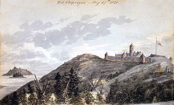
Pond's confidence outlasted his departure from the west. In Quebec in November 1789, before news of the voyage reached the east, he told Isaac Ogden, who passed it on in a letter to his father, that another man named McKenzie had been left at Great Slave Lake with orders to go down the river, on to Unalaska and Kamchatka, and home to England through Russia. Mackenzie's own title for his journal confirms that he went under orders, describing a voyage "performed by Order of the N.W. Company" in search of a water passage from Athabasca to the Pacific.[11] He also wanted to go. Years later he called the crossing of the continent "this favourite project of my own ambition."[12] His cousin Roderick McKenzie, who had declined to return to the interior in 1788, agreed only when Mackenzie told him in confidence that unless Roderick took charge of the department, the voyage would have to be abandoned.[13] Roderick built a new post, Fort Chipewyan, on the south shore of Lake Athabasca, and Mackenzie joined him there shortly before Christmas.[14]
Down the Grand River
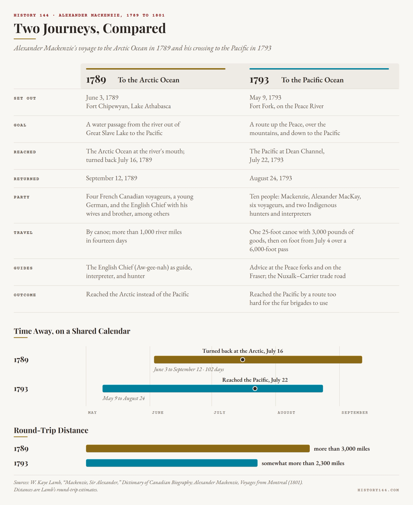
Mackenzie left Fort Chipewyan on June 3, 1789. With him went four French Canadian voyageurs, a young German whose presence no one has explained, and a Chipewyan leader whom the traders called the English Chief.[15] The English Chief's name is recorded as Aw-gee-nah. Nearly twenty years earlier he had traveled with Matonabbee when that leader guided the Hudson's Bay Company's Samuel Hearne to the Coppermine River, and since about 1786 he had worked for the North West Company as a middleman. Accompanied by two wives and his brother, he served Mackenzie as guide, interpreter, and hunter, and he could speak with the Slavey, Dogrib, and Beaver peoples along the route.[16]
Once the canoes left Great Slave Lake and entered the river flowing out of it, they covered more than a thousand miles in fourteen days. For nearly three hundred miles the river ran west, as Pond had predicted. Then, at what is now called Camsell Bend, it swung north and kept going north, day after day. By July 10, two days from the sea, Mackenzie understood what that meant. "I am much at a loss here how to act," he wrote, since going farther "will not answer the Purpose of which the Voyage was intended, as it is evident these Waters must empty themselves into the Northern Ocean." He went on anyway, because reaching the river's mouth "would satisfy Peoples Curiosity tho' not their Intentions."[17]
He camped for four nights on an island off the river's mouth that he named Whale Island, now Garry Island, for the white whales he saw nearby, and he watched the water rise and fall with the tide. The party turned back on July 16 and reached Fort Chipewyan on September 12, completing a round trip of more than three thousand miles in 102 days.[18] Mackenzie drove his men hard, and at least one later writer judged that he treated them as mere instruments, but his journal suggests a more mixed picture. When it was still uncertain that they would see the sea, he recorded that his men had marched exceedingly hard without grumbling and declared themselves ready to go with him "wherever I choose to lead them." He brought every one of them home, and two of the four voyageurs signed on for his second expedition.[19]
The voyage served the English Chief's purposes too. He saw a chance to carry beaver pelts from the peoples of the Liard and Mackenzie country to the company's posts. Like Matonabbee before him, in the historian W. A. Sloan's account, he showed no reluctance to plunder weaker neighbors such as the Hare and Dogrib, who were intimidated by firearms. On his return he had prestige enough to lead a band of Yellowknife middlemen, and the Yellowknives went on carrying goods between the traders and more distant peoples until 1823.[20] Mackenzie had a hand in that rise. "It will be proper to appoint a chief among the Red Knives," as the traders called the Yellowknives, he wrote to Roderick in March 1791. "I think the English Chief may answer, as none of their own principal men can have sufficient authority."[21]
"Hardly Spoken Of"
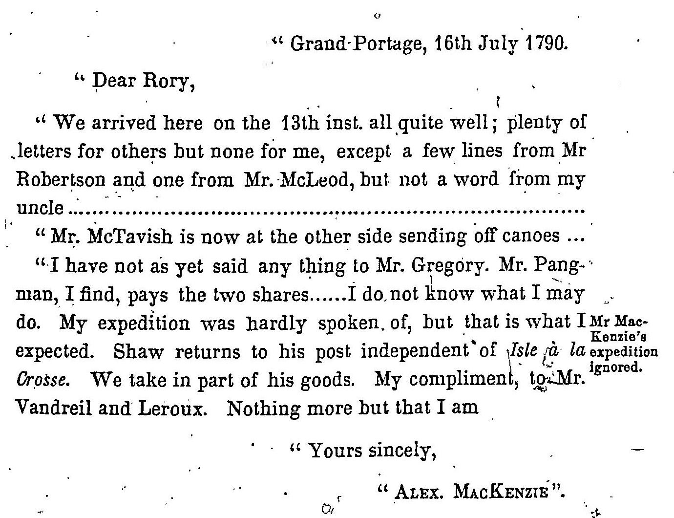
Mackenzie had become the first European on record to reach the Arctic Ocean by paddling the length of a great river, but his first reaction was frustration.[22] At the partners' annual meeting at Grand Portage, on Lake Superior, in 1790, he wrote to Roderick: "My expedition was hardly spoken of, but that is what I expected."[23] The partners valued him nonetheless, and a new agreement, to take effect in 1792, doubled his holding to two shares. According to a frequently repeated story, he named his discovery the River Disappointment, but the evidence is thin. The name appears in only one of four surviving transcripts of the letter in which he supposedly used it, and the other three call it the Grand River.[24] A letter of March 1791, printed in 1889 in L. R. Masson's collection of fur-trade papers, does use the name, but only in passing, in a proposal to send men trading "down the River Disappointment."[25]
Another encounter that summer stung more. At Cumberland House, on the Saskatchewan River, Mackenzie met Philip Turnor, a trained surveyor working for the Hudson's Bay Company, who noted afterward that Mackenzie claimed to have been at the sea but seemed so unfamiliar with astronomical observations that Turnor doubted he knew where he had been.[26] Mackenzie did know, but he had no means of fixing longitude. He admitted in print that on the first voyage he had lacked "the necessary books and instruments" and had felt himself deficient in astronomy and navigation, and that he had made "a winter's voyage" to England to remedy both.[27] He spent the winter of 1791–92 in London and returned with a compass, a sextant, a chronometer, and a large telescope. He also now knew what Pond had not. Turnor had fixed the true longitude of Fort Chipewyan, and when it was compared with Cook's readings on the coast, the real distance to the Pacific became clear.[28]
Up the Peace
For his second attempt Mackenzie would ascend the Peace River to its source in the mountains, cross the divide, and look for a river on the western slope that would carry him to the sea. He left Fort Chipewyan on October 10, 1792, and spent the winter at an advance post called Fort Fork, near the junction of the Peace and Smoky Rivers in what is now Alberta.[29] In January he asked Roderick to send a navigation manual and his sextant, with all the quicksilver Roderick had, "as I have lost all mine," and suggested that a young clerk, Alexander MacKay, "would be of great service to me should I undertake my expedition."[30] MacKay arrived on April 12 and became his second in command.[31]
On May 8 and 9, as he made ready, Mackenzie wrote Roderick a troubled letter. "I have been so vexed and disturbed of late, that I cannot sit down to any thing steadily," it began. He had struggled to find young men willing to go; a volunteer he had refused had persuaded his guide to run away; and the two who remained knew no more of the country than he did. "Without Indians I have little hopes of success," he admitted, yet "we are too far advanced in the undertaking not to make the attempt." He sent Roderick a couple of guineas and took the rest "to traffic with the Russians."[32]
They set out at seven in the evening of May 9, 1793, in a single birchbark canoe, twenty-five feet long, that carried three thousand pounds of provisions, trade goods, arms, ammunition, and baggage, along with ten people. Mackenzie listed them by name: MacKay; the voyageurs Joseph Landry, Charles Ducette, François Beaulieux, Baptiste Bisson, François Courtois, and Jacques Beauchamp; and two Indigenous men who served as hunters and interpreters.[33]
By the end of May the party had reached the point where the Parsnip and Finlay Rivers join to form the Peace. An old man advised Mackenzie to take the Parsnip, telling him that a carrying place at its head would lead over a height of land to a large river flowing west. The advice proved sound, but the small streams and lakes linking the two watersheds were brutal going, and Mackenzie gave one of them, now James Creek, the name Bad River. On June 18 he reached a large river flowing south. Not knowing that any such river existed, he took it for the upper waters of the Columbia. It was the Fraser.[34] The previous autumn, a boat party from Vancouver's expedition under Lieutenant Broughton had rowed about a hundred miles up the real Columbia and formally taken possession of the river and the country around it in the king's name.[35]
The Road to the Sea
Four days later, near the site of the later Fort Alexandria, the people living along the river urged Mackenzie not to go on. Parts of the river, they said, were nearly impassable, and its mouth lay far to the south. The better way to the ocean was overland, by a much shorter route: back upriver to the West Road River and then west along its valley. He feared that turning back would look like retreat. "In a voyage of this kind," he wrote, "a retrograde motion could not fail to cool the ardour, slacken the zeal, and weaken the confidence of those, who have no greater inducement in the undertaking, than to follow the conductor of it." He took the advice anyway, and on June 23 the party started back upriver.[36]
By July 4 they had cached the canoe and surplus supplies near the mouth of the West Road River and set off on foot, Mackenzie carrying about seventy pounds of pemmican and other provisions as well as his arms, ammunition, and telescope. For most of the way they followed well-beaten Indigenous trails.[37] The route belonged to a network that Nuxalk and Carrier peoples had used for perhaps four thousand years or more, carrying eulachon grease, obsidian, hides, salmon, and other goods between the interior and the coast. A stretch of about 420 kilometers of it, from the Fraser to the Bella Coola valley, is known today both as the Alexander Mackenzie Heritage Trail and as the Nuxalk-Carrier Grease Trail.[38] Mackenzie reached the Pacific as a stranger on a long-established trade road.
West of the Tanya Lakes he chose to follow the Bella Coola River rather than the Dean, crossing on the way a pass of about six thousand feet, the highest point of either journey. On July 17 he came down into the deep valley of the Bella Coola and was welcomed at a settlement he named Friendly Village. Two days later, after traveling down the turbulent river, he came upon six houses built on posts about twenty-five feet high. "From these houses," he wrote, "I could perceive the termination of the river, and its discharge into a narrow arm of the sea."[39] He had reached the Pacific at the head of a long inlet, not on the open ocean.
Dean Channel
The coast proved less welcoming than the valley. The people Mackenzie met near the mouth of the Bella Coola, whom he called Bella Bellas and who are now known as the Heiltsuk, were hostile, and open fighting was narrowly averted. He obtained a canoe and paddled down North Bentinck Arm into Dean Channel, where he met the man who spoke of Macubah. None of the journals of Vancouver's expedition mention trouble with the people there, and the identity of a second man the speaker named, Bensins, remains uncertain.[40] After the night on the rock and the painted inscription, the party started home on July 23. That morning the men came close to mutiny, seized by what Mackenzie called "frantic terror" at the threatening people and the dangerous ground ahead.[41]
They were back at Fort Chipewyan on August 24, having covered somewhat more than 2,300 miles in all. Mackenzie had again brought his crew home safe, and on neither expedition had he fired a shot in anger.[42]
The rock is still there, near Elcho Harbour, in what is now Sir Alexander Mackenzie Provincial Park. Surveyors later cut the words permanently into the stone.[43] The carved text is shorter than the sentence printed in Mackenzie's book, a reminder that the inscription, like much about the journey, reaches readers through later hands.[44]
A Restless Partner
Once again, Mackenzie's route was of no immediate use to his company. The routes that later carried the fur brigades across the mountains were found by Simon Fraser and David Thompson. The winter after his return was hard. Alone for long stretches at Fort Chipewyan, he seems to have come close to a breakdown.[45] In January 1794 he described himself to Roderick as "starving and alone, without the power of doing myself or any body else any good," and declared himself "fully bent upon going down, for I think it unpardonable for any body to remain in this country who can leave it." In March he wrote that the previous autumn "the greatest part of my time was engaged in vain speculation." He had walked "backward and forward, musing for hours," and could scarcely close his eyes "without finding myself in company with the dead."[46]
He did not mean to leave the trade. On his way to Montreal in September 1794 he called on John Graves Simcoe, lieutenant governor of Upper Canada, and outlined a plan in which the North West Company, the Hudson's Bay Company, and the East India Company would cooperate. The plan was set aside when Mackenzie accepted a partnership in McTavish, Frobisher and Company, the Montreal firm through which Simon McTavish handled the North West Company's supplies and fur sales and controlled a majority of its shares.[47]
The partnership took effect in 1795, and each spring Mackenzie traveled to Grand Portage to meet the wintering partners. Many of the winterers disliked McTavish, whom they called "the Premier" or "the Marquis" for his haughty manner.[48] Increasingly Mackenzie sided with them against his fellow agents in Montreal, and his renewed interest in shipping furs through Hudson Bay or the Pacific brought him into growing conflict with McTavish, whose interests were bound to the Montreal route. By 1799 he was again in a highly nervous state. At Grand Portage that summer, according to Roderick, he told the partners that, "feeling himself uncomfortable," he would not renew his engagement. The wintering partners resolved unanimously that they could not dispense with his services, but he would not be moved, and when his partnership expired on November 30 he left abruptly for England.[49] A rival concern, the New North West Company, later known as the XY Company, had formed in 1798, and Mackenzie acquired shares in it by 1800.[50]
The Book
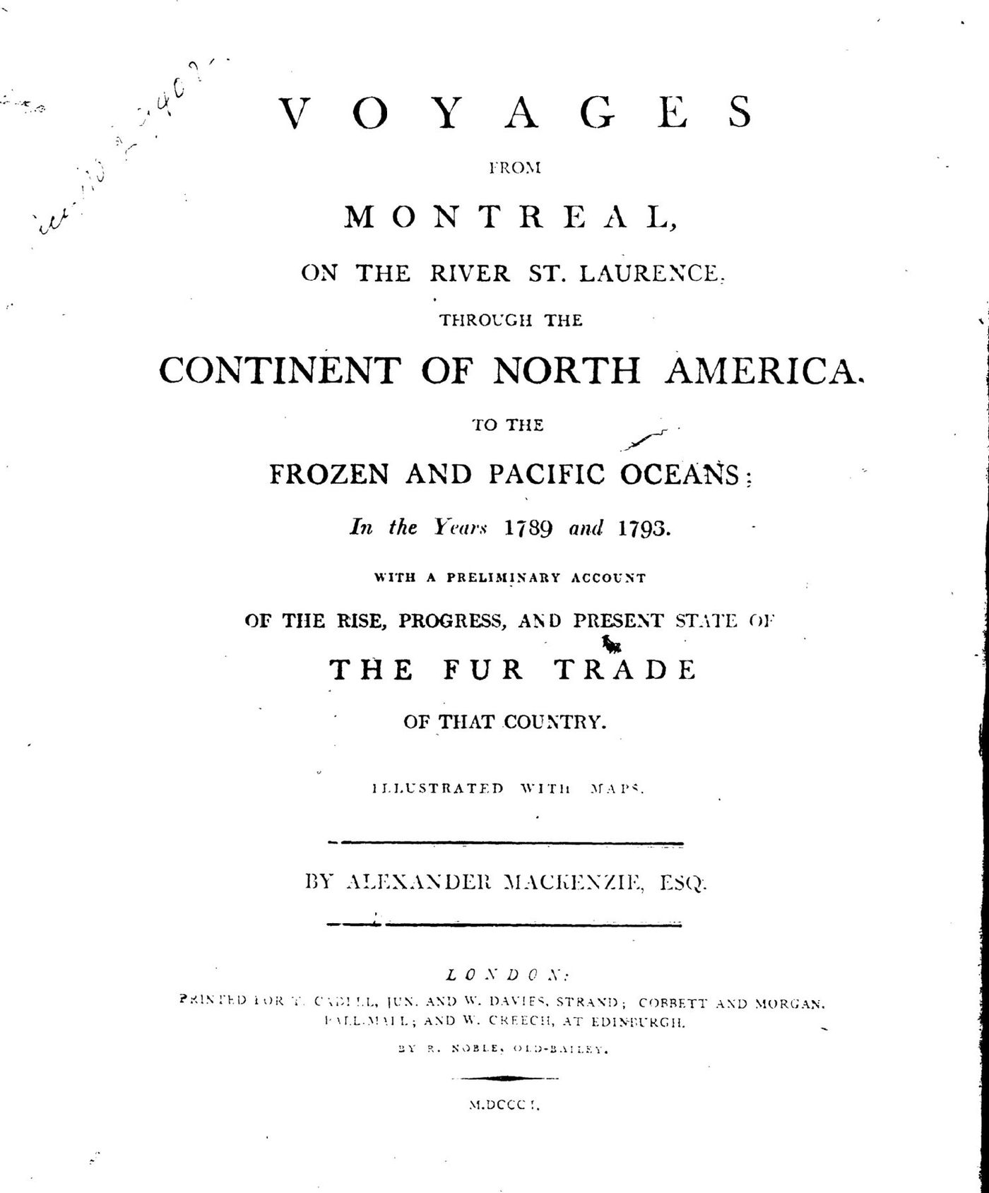
In London he set about publishing his travels, with help. The journals were edited by the prolific writer William Combe, and the long history of the fur trade that opened the book may have been written largely by Roderick McKenzie.[51] Mackenzie signed his preface on November 30, 1801, two years to the day after his partnership with McTavish expired. In it he described himself as "much better calculated to perform the voyages, arduous as they might be, than to write an account of them," and insisted that he was "not a candidate for literary fame."[52]
Voyages from Montreal appeared in December 1801, drew wide attention, and was soon reprinted and translated.[53] The preface claimed more for the journeys than their sponsors had seen in them. The first voyage, Mackenzie wrote, had settled the question of a practicable Northwest Passage, and the second had proved "the practicability of a commercial communication" across the continent.[54] In its final pages he returned to the plan he had put to Simcoe. With regular establishments through the interior and on the Pacific, he argued, Britain could gain "the entire command of the fur trade of North America" from the forty-eighth parallel to the pole.[55]
On February 10, 1802, Mackenzie was knighted.[56] The book soon reached readers beyond Britain. Thomas Jefferson read it in the summer of 1802. In the judgment of the historian Arlen Large, he saw in Mackenzie's call for government-protected ports in the Pacific Northwest, shipping furs to China, a challenge that the United States could meet with a more southerly route along the Missouri and Columbia Rivers. In January 1803 he asked Congress for money to send an expedition west, telling it that an intelligent officer with ten or twelve chosen men should be enough, a party about the size of Mackenzie's.[57]
The Rock and the Book
Seen from the end of 1801, Mackenzie's twelve years look less like a triumph than like a long argument with geography. He set out in 1789 with a map that put the Pacific within easy reach of Great Slave Lake and spent four years learning how wrong it was. His second journey reached the Pacific only by rapids, portages, and footpaths that no company could use to move freight, and the most powerful of the partners who sent him became his adversary. When the rival companies united in 1804 he was excluded from the combined concern and so shut out of the Canadian fur trade, and only after his death did the reorganized Hudson's Bay Company adopt much of his plan for a trade spanning the continent.[58]
The journeys mattered nonetheless. They show how thoroughly European exploration of the northwest depended on Indigenous knowledge. Pond's map was right where it followed what his informants told him and wrong where he set them aside. The English Chief guided the first voyage and turned it to his own advantage. An old man at the forks of the Peace pointed the way over the divide, and the people on the Fraser sent Mackenzie to the sea along a trade road far older than the fur trade. In the book of 1801, a fur trader's travels became an argument about who would control the northwest, and that argument crossed the Atlantic and helped set an American expedition in motion.
The words Mackenzie painted on the rock in Dean Channel did not name the North West Company or the king. They said "from Canada, by land," recording what was genuinely new, that a small party had crossed from the fur posts of the interior to the western sea. Surveyors later cut his words into the stone, but the inscription most readers came to know was the version he gave the world eight years later, edited, argued, and printed in London, which taught readers on both sides of the Atlantic to see the far northwest as a prize within reach.
Places in this Story
The places this story moves through, in order — follow them on the interactive map →
- Fort Chipewyan (Old Fort Point), Lake Athabasca, Alberta June 3, 1789
Mackenzie leaves the new fort with voyageurs and the Chipewyan leader Aw-gee-nah (the English Chief) to follow the river out of Great Slave Lake.
- Camsell Bend, Mackenzie River, Northwest Territories July 1789
After nearly 300 miles flowing west as Pond predicted, the river turns north toward the Arctic.
- Garry Island ("Whale Island"), Mackenzie Delta, Northwest Territories Mid-July 1789
He camps four nights at the river's mouth, sees white whales and the tide, and turns back on July 16.
- Quebec City November 1789
Peter Pond tells Isaac Ogden that Mackenzie is headed for the Pacific, not knowing he has already reached the Arctic.
- Cumberland House, Saskatchewan June 1790
Surveyor Philip Turnor doubts Mackenzie knows where he has been, which pushes him to go to London for training and instruments.
- Grand Portage, Minnesota (Lake Superior) July 16, 1790
At the partners' annual meeting he writes that his expedition "was hardly spoken of, but that is what I expected."
- Fort Fork, Peace River, Alberta May 9, 1793
He sets out in one birchbark canoe carrying ten people and three thousand pounds of supplies.
- Finlay Forks (Finlay–Parsnip confluence), British Columbia Late May 1793
An old man advises him to take the Parsnip River over the divide; the site is now under Williston Lake.
- Near Alexandria, Fraser River, British Columbia June 22, 1793
Local people warn him the river is impassable and direct him to a shorter overland route to the sea.
- Mouth of the West Road (Blackwater) River, British Columbia July 4, 1793
He caches his canoe and sets off on foot along the ancient Nuxalk–Carrier trade road.
- Mackenzie's Rock, Dean Channel, British Columbia July 22, 1793
He paints "Alexander Mackenzie, from Canada, by land" on a rock, completing the first recorded crossing of North America north of Mexico.
- London, England November 30, 1801
He signs the preface to Voyages from Montreal, the book Thomas Jefferson reads the following summer.
Important Dates
Mackenzie leaves Fort Chipewyan with French Canadian voyageurs and the Chipewyan leader Aw-gee-nah (the English Chief), hoping the river out of Great Slave Lake will lead to the Pacific.
In Quebec, Peter Pond confidently tells Isaac Ogden that Mackenzie has been sent down the river from Great Slave Lake to reach the Pacific, not knowing that Mackenzie had already found it flows to the Arctic and was back at Fort Chipewyan.
Writing from the partners' annual meeting at Grand Portage, Mackenzie tells his cousin Roderick that his voyage to the Arctic Ocean "was hardly spoken of, but that is what I expected."
He spends the winter in London learning astronomy and navigation and buying instruments, after the surveyor Philip Turnor doubted that he knew where he had been. (No exact date survives.)
He sets out from Fort Fork on the Peace River in a single birchbark canoe carrying ten people and three thousand pounds of supplies, the day after writing that he was "too far advanced in the undertaking not to make the attempt."
At Dean Channel on the Pacific coast, he paints on a rock the words "Alexander Mackenzie, from Canada, by land," completing the first recorded crossing of North America north of Mexico.
On his way to Montreal, he calls on Lieutenant Governor John Graves Simcoe of Upper Canada and proposes that the North West, Hudson's Bay, and East India companies cooperate in a continent-wide fur trade.
His partnership in McTavish, Frobisher and Company takes effect, and each spring he travels to Grand Portage to meet the wintering partners.
Rival Montreal traders form the New North West Company, later called the XY Company, in which Mackenzie acquires shares by 1800.
His partnership with Simon McTavish expires, and he leaves abruptly for England even though the wintering partners had voted unanimously to keep him.
He signs the preface to Voyages from Montreal in London; the book appears that December, and Thomas Jefferson reads it the following summer.
Frequently Asked Questions
Who was Alexander Mackenzie?
Sir Alexander Mackenzie (1764–1820) was a Scottish-born fur trader, explorer, and partner in Montreal's North West Company. He is best known for following the Mackenzie River to the Arctic Ocean in 1789 and crossing North America to the Pacific in 1793, and he was knighted in 1802.
What did Alexander Mackenzie discover?
In 1789 Mackenzie traveled more than a thousand miles down the river that now bears his name, becoming the first European on record to reach the Arctic Ocean that way. In 1793 he crossed the Rocky Mountains and reached the Pacific at Dean Channel, British Columbia, completing the first recorded crossing of North America north of Mexico.
What does Mackenzie's Rock say?
On July 22, 1793, Mackenzie painted "Alexander Mackenzie, from Canada, by land, the twenty-second of July, one thousand seven hundred and ninety-three" on a rock in Dean Channel, using vermilion mixed with melted grease. Surveyors later carved the words permanently into the stone, which stands near Elcho Harbour in Sir Alexander Mackenzie Provincial Park.
Did Mackenzie call the Mackenzie River the "River of Disappointment"?
The story is widely repeated, but only one of four surviving copies of the letter in question uses the name, and the other three call it the Grand River. A March 1791 letter published in 1889 does mention the "River Disappointment," but only in passing, in a plan to send traders down it.
Who guided Alexander Mackenzie on his expeditions?
On the 1789 Arctic voyage, the Chipewyan leader Aw-gee-nah, known to the traders as the English Chief, served as Mackenzie's guide, interpreter, and hunter. In 1793, people living along the Fraser River directed him to a shorter overland route to the Pacific, an ancient Nuxalk and Carrier trade road now called the Grease Trail.
Did Alexander Mackenzie meet George Vancouver?
No: Captain George Vancouver explored Dean Channel on June 2, 1793, about seven weeks before Mackenzie arrived there by land. A local man told Mackenzie about a large ship and a man he called "Macubah," who was very probably Vancouver.
How did Alexander Mackenzie influence Lewis and Clark?
Thomas Jefferson read Mackenzie's 1801 book Voyages from Montreal in the summer of 1802, and historian Arlen Large argues that he saw its call for a British-backed Pacific fur trade as a challenge to the United States. In January 1803 Jefferson asked Congress to fund an American expedition west with an officer and ten or twelve men, a party about the size of Mackenzie's.
Bibliography
BC Geographical Names. "Nuxalk Carrier Grease Trail." Province of British Columbia. Accessed October 3, 2026. https://apps.gov.bc.ca/pub/bcgnws/names/68181.html.
BC Parks. "Sir Alexander Mackenzie Park." Province of British Columbia. Accessed October 3, 2026. https://bcparks.ca/sir-alexander-mackenzie-park/.
Gough, Barry M. "Pond, Peter." In Dictionary of Canadian Biography, vol. 5. University of Toronto/Université Laval, 1983. Accessed October 5, 2026. https://www.biographi.ca/en/bio/pond_peter_5E.html.
Lamb, W. Kaye. "Mackenzie, Sir Alexander (1764–1820)." In Dictionary of Canadian Biography, vol. 5. University of Toronto/Université Laval, 1983. Accessed October 3, 2026. https://www.biographi.ca/en/bio/mackenzie_alexander_5E.html.
Large, Arlen J. "Mackenzie's Canada Crossing." Discover Lewis & Clark, Lewis and Clark Fort Mandan Foundation. Accessed October 3, 2026. https://lewis-clark.org/related-explorers/mackenzies-canada-crossing/.
Mackenzie, Alexander. Voyages from Montreal Through the Continent of North America to the Frozen and Pacific Oceans in 1789 and 1793. 2 vols. New York: A. S. Barnes, 1903. Project Gutenberg, EBooks 35658 and 35659. Accessed October 3, 2026. https://www.gutenberg.org/ebooks/35658; https://www.gutenberg.org/ebooks/35659. First published as Voyages from Montreal, on the River St. Laurence, through the Continent of North America, to the Frozen and Pacific Oceans; in the Years 1789 and 1793 (London: T. Cadell, Jun., and W. Davies; Cobbett and Morgan; and W. Creech, at Edinburgh, 1801); title page of the first edition consulted at Canadiana, https://www.canadiana.ca/view/oocihm.33950.
Masson, L. R., ed. Les bourgeois de la Compagnie du Nord-Ouest: Récits de voyages, lettres et rapports inédits relatifs au Nord-Ouest canadien. 2 vols. Quebec: Imprimerie générale A. Coté, 1889–90. Volume 1 includes Roderic McKenzie, "Reminiscences," with his copies of letters from Alexander Mackenzie. Internet Archive. Accessed October 5, 2026. https://archive.org/details/P000159.
Morrison, Jean. "MacKay (McKay), Alexander (d. 1811)." In Dictionary of Canadian Biography, vol. 5. University of Toronto/Université Laval, 1983. Accessed October 3, 2026. https://www.biographi.ca/en/bio/mackay_alexander_5E.html.
Parks Canada. "Sir Alexander Mackenzie (c. 1762–1820)." Backgrounder, February 15, 2016. Accessed October 3, 2026. https://www.canada.ca/en/parks-canada/news/2016/02/sir-alexander-mackenzie-c-1762-1820-.html.
Princeton University Library. "Mackenzie: 1789, 1792–1797." Northwest Passage exhibition, Western Americana Collection. Accessed October 3, 2026. https://static-prod.lib.princeton.edu/visual_materials/maps/websites/northwest-passage/mackenzie.htm.
Sloan, W. A. "Aw-gee-nah (English Chief)." In Dictionary of Canadian Biography, vol. 6. University of Toronto/Université Laval, 1987. Accessed October 3, 2026. https://www.biographi.ca/en/bio/aw_gee_nah_6E.html.
Vancouver, George. A Voyage of Discovery to the North Pacific Ocean, and Round the World. New ed., with corrections. 6 vols. London: John Stockdale, 1801. Vol. 3. Internet Archive. Accessed October 5, 2026. https://archive.org/details/voyagediscoveryt00vanc.
Citations
- Lamb, "Mackenzie, Sir Alexander"; Mackenzie, Voyages from Montreal, vol. 2 (page number not confirmed). Lamb gives Mackenzie's age as twenty-nine on his return from the Pacific in 1793. Lamb gives the interval between the two expeditions as "a little more than six weeks," but Vancouver's June 2 date and Mackenzie's arrival in Dean Channel on July 21 make it forty-nine days, or seven weeks. ↑
- Lamb, "Mackenzie, Sir Alexander" (1764); Parks Canada, "Sir Alexander Mackenzie (c. 1762–1820)" (circa 1762). ↑
- Lamb, "Mackenzie, Sir Alexander." ↑
- Lamb, "Mackenzie, Sir Alexander." ↑
- Mackenzie, Voyages from Montreal, 1:xliv–xlv. ↑
- Lamb, "Mackenzie, Sir Alexander." ↑
- Lamb, "Mackenzie, Sir Alexander"; Gough, "Pond, Peter." Gough notes that historians disagree over whether Pond ever stood trial for the death of Jean-Étienne Waddens in 1782, and that evidence points to a man named Péché as the one who shot Ross. Roderick McKenzie, who knew Pond, wrote that he left the country in 1788 "on his defence," having been accused "of having been instrumental towards the death of two gentlemen who were in opposition to his interest." Roderic McKenzie, "Reminiscences," in Masson, Les bourgeois, 1:26. ↑
- Lamb, "Mackenzie, Sir Alexander." ↑
- Pat. Small to Simon McTavish, February 24, 1788, in Masson, Les bourgeois, 1:25. ↑
- Lamb, "Mackenzie, Sir Alexander." ↑
- Lamb, "Mackenzie, Sir Alexander." ↑
- Mackenzie, Voyages from Montreal, 1:viii. ↑
- Roderic McKenzie, "Reminiscences," in Masson, Les bourgeois, 1:27. In Roderick's account, Mackenzie described the planned voyage as one to "the Northern Ocean," not the Pacific named in the title of his journal. ↑
- Lamb, "Mackenzie, Sir Alexander." ↑
- Lamb, "Mackenzie, Sir Alexander." ↑
- Sloan, "Aw-gee-nah (English Chief)." ↑
- Lamb, "Mackenzie, Sir Alexander." The quotations from the 1789 journal in this article come from Mackenzie's manuscript journal as quoted by Lamb; they do not appear in this form in the Voyages, whose text of the first journal was revised for publication. Mackenzie's letters to Roderick McKenzie survive only in copies. They are quoted here from the versions printed in Masson, Les bourgeois, vol. 1, and the notes record where Lamb's transcripts read differently. ↑
- Lamb, "Mackenzie, Sir Alexander." ↑
- Lamb, "Mackenzie, Sir Alexander." The harsher judgment is that of Joseph Burr Tyrrell, which Lamb quotes and calls unduly harsh. ↑
- Sloan, "Aw-gee-nah (English Chief)." ↑
- Mackenzie to Roderick McKenzie, March 2, 1791, in Masson, Les bourgeois, 1:36. ↑
- Parks Canada, "Sir Alexander Mackenzie (c. 1762–1820)." ↑
- Mackenzie to Roderick McKenzie, July 16, 1790, in Masson, Les bourgeois, 1:35. Lamb, "Mackenzie, Sir Alexander," quoting a manuscript transcript of the same letter, gives "My Expedition is hardly spoken of but this is what I expected." ↑
- Lamb, "Mackenzie, Sir Alexander." Some modern accounts repeat the name as fact; see, for example, Princeton University Library, "Mackenzie: 1789, 1792–1797." ↑
- Mackenzie to Roderick McKenzie, March 2, 1791, in Masson, Les bourgeois, 1:36. Masson's footnote identifies the river as "the Grand River, or MacKenzie River." ↑
- Lamb, "Mackenzie, Sir Alexander." ↑
- Mackenzie, Voyages from Montreal, 1:ix. ↑
- Lamb, "Mackenzie, Sir Alexander." ↑
- Lamb, "Mackenzie, Sir Alexander." ↑
- Mackenzie to Roderick McKenzie, January 10, 1793, in Masson, Les bourgeois, 1:40–41. Masson notes that the letter is "much abridged." Morrison, "MacKay (McKay), Alexander," quoting another copy, gives the last phrase as "should I undertake any expedition." A footnote in Masson records that Mackenzie's sextant and chronometer were "still preserved in the family at Terrebonne" when the volume was published. ↑
- Morrison, "MacKay (McKay), Alexander." ↑
- Mackenzie to Roderick McKenzie, May 8–9, 1793, in Masson, Les bourgeois, 1:41–43. ↑
- Mackenzie, Voyages from Montreal, 2:30–31; Lamb, "Mackenzie, Sir Alexander." ↑
- Lamb, "Mackenzie, Sir Alexander." ↑
- Vancouver, Voyage of Discovery, 3:85, 108–9. Broughton put the distance at eighty-four miles from what he took to be the river's entrance and one hundred miles from his ship, the Chatham. He believed that no subjects of any other "civilized nation or state" had entered the river before him, judging from a sketch by the American trader Robert Gray that did not show Gray within five leagues of its entrance. Gray had in fact sailed into the river that May. ↑
- Lamb, "Mackenzie, Sir Alexander"; Mackenzie, Voyages from Montreal, vol. 2 (page number not confirmed). The journal of the second expedition survives only in the version William Combe edited for the Voyages, so the quotations from it here come from that published text. ↑
- Lamb, "Mackenzie, Sir Alexander." ↑
- BC Geographical Names, "Nuxalk Carrier Grease Trail." ↑
- Lamb, "Mackenzie, Sir Alexander"; Mackenzie, Voyages from Montreal, vol. 2 (page number not confirmed). ↑
- Lamb, "Mackenzie, Sir Alexander." ↑
- Morrison, "MacKay (McKay), Alexander"; Mackenzie, Voyages from Montreal, vol. 2 (page number not confirmed). ↑
- Lamb, "Mackenzie, Sir Alexander." ↑
- BC Parks, "Sir Alexander Mackenzie Park"; Lamb, "Mackenzie, Sir Alexander." ↑
- BC Parks, "Sir Alexander Mackenzie Park," gives the inscription as "Alex Mackenzie from Canada by land 22nd July 1793"; compare the printed text in Mackenzie, Voyages from Montreal, vol. 2 (page number not confirmed). The BC Geographical Names entry cited in note 38 gives the year of the inscription as 1783, an evident error. ↑
- Lamb, "Mackenzie, Sir Alexander." ↑
- Mackenzie to Roderick McKenzie, January 13 and March 5, 1794, in Masson, Les bourgeois, 1:44–45. Lamb, "Mackenzie, Sir Alexander," quoting manuscript transcripts of these letters, gives slightly different wording, including "unpardonable in any man to remain in this country who can afford to leave it." ↑
- Lamb, "Mackenzie, Sir Alexander." ↑
- Roderic McKenzie's footnote in Masson, Les bourgeois, 1:44. ↑
- Roderic McKenzie, "Reminiscences," in Masson, Les bourgeois, 1:48; Lamb, "Mackenzie, Sir Alexander." ↑
- Lamb, "Mackenzie, Sir Alexander." ↑
- Lamb, "Mackenzie, Sir Alexander"; Large, "Mackenzie's Canada Crossing." ↑
- Mackenzie, Voyages from Montreal, 1:viii, xiii. ↑
- Lamb, "Mackenzie, Sir Alexander." ↑
- Mackenzie, Voyages from Montreal, 1:ix. ↑
- Lamb, "Mackenzie, Sir Alexander," confirms that Mackenzie outlined this proposal in the last pages of the Voyages. For the quoted words: Princeton University Library, "Mackenzie: 1789, 1792–1797." The closing pages of the Voyages could not be consulted directly for this article, so the quotation is given as reported by Princeton. ↑
- Lamb, "Mackenzie, Sir Alexander." ↑
- Large, "Mackenzie's Canada Crossing." ↑
- Lamb, "Mackenzie, Sir Alexander." ↑